Showing posts with label Training for EBC. Show all posts

Wednesday, 2 January 2013

Sri Pada aka Adam's Peak aka Samanalakande

Sunrise, Adam's Peak Sri Lanka
Sunrise, Adam's Peak
Way up to Adam's Peak.
Up early again this morning. 1:45am. We rugged up and headed down the road towards the beginning of the walking path which leads to Adam's Peak. We didn't even make it that far before we were stripping off layers of clothing.

At 2243m, Adam's Peak is hefty. And as we glimpsed it lit up this morning, it looked no less intimidating than it had as we ate dinner last night and watched its peak peep through, above the clouds.

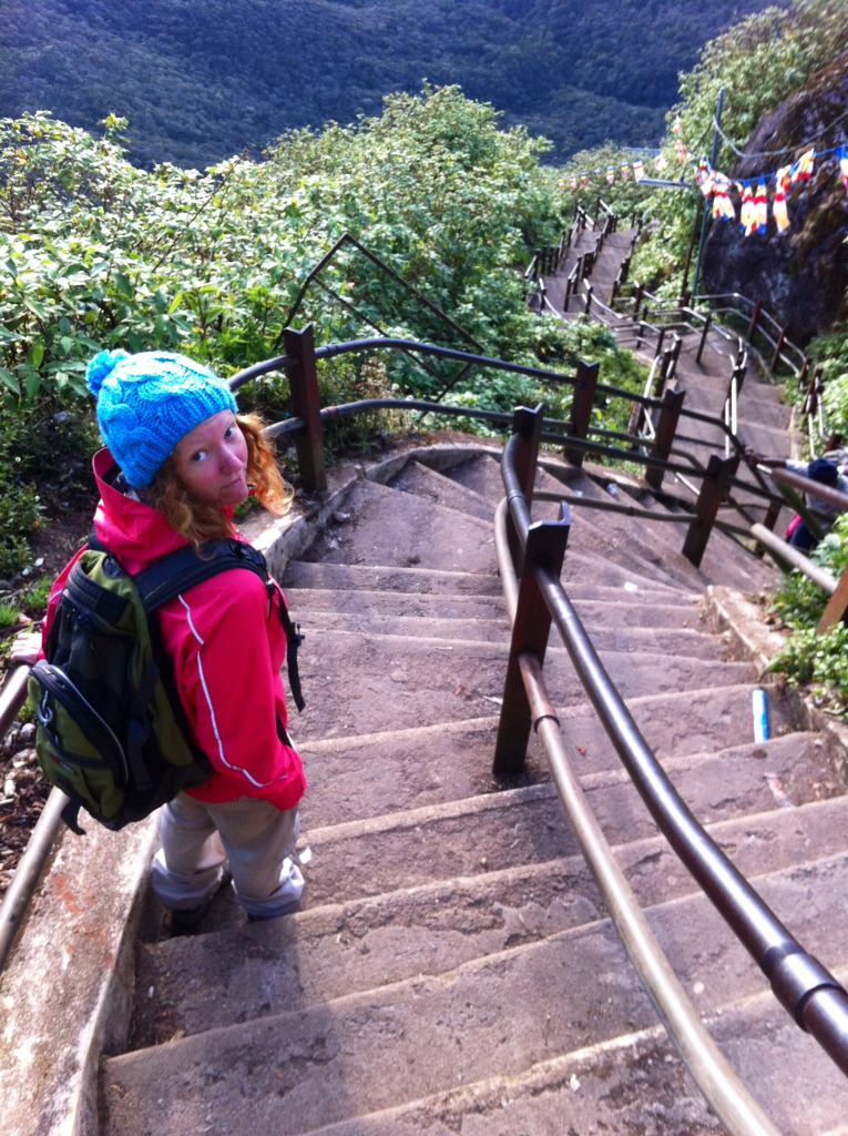
The walk eases you into it with gradual inclines and only short sections of stairs. Before long though the real stuff is well and truly upon you. The second half of the walk is stairs, stairs and more stairs. Steep stairs, small stairs, large stairs, crumbling stairs, rocky stairs, concrete stairs. 5200 of them. Some sections are so steep the stairs seem to bulge out at you. Our rest stops gradually increased in regularity as the stairs got steeper. There were points where we could barely go up 10m before stopping again. And we weren't the only ones. The stairs were scattered with resting tourists trying to catch their breath. We figure the reason the walk up is so quiet is because nobody can catch their breath long enough to utter more than a few words at any one time. Needless to say, your thighs suffer incredibly. But, you do get into some kind of rhythm for some stretches, where your mind seems to disconnect from your legs and simply put one put infront of the other. Luckily there's a handrail when you are close to the top and most tired so your arms can take over from your thighs slightly. We passed many stalls on the way up. Mostly they sold useless plastic toys and fake flowers but some sold water and chocolate which was pretty tempting. We stuck with our pre-packed snacks though, rewarding ourselves with snacks once we reached the top.

Just some of the 5200 stairs.
Tourist!
We made it woooo.
We arrived at the top ahead of schedule and it was freezing. We secured ourselves a good spot for sunrise and re-layered our clothes back on. We took in a cloudy sunrise with many other people, grateful we weren't there the day before for New Years Eve as it was apparently even busier. Drummers drummed and men chanted as the sun slowly began to warm our bones.

Adam's Peak is a sacred place for both Christians and Buddhists. We checked out Buddah's footprint and watched a pilgrims came to pray.

It is customary to ring a bell at the top of Adam's Peak according to the number of times you have climbed it. We left it a bit late though and by the time I went to ring it the rest of the tourists had all descended so I felt a bit like a naughty little kid doing something I wasn't meant to.

Ringing the bell.
Pilgrims ascending Adam's Peak.
We started our descent at about 7am. Coming down is not easy as your knees take the load and your thighs begin shaking uncontrollably. However, we couldn't complain too much as we passed throngs of pilgrims making the climb barefoot, some of which were elderly to say the least. On top of that, there were guys carrying up huge bags of gravel and sand to fix the stairs on the walking track. They must have been paid by the kilo as each had their bag weighed when they reached their destination. 36kg was just one we overheard. There were also people carrying up babies and small children and what we can only assume we're guys training for the army who carried up heavy backpacks. So really, we had it pretty easy in comparison but it sure didn't feel like it at the time.


Looking over the clouds at Adam's Peak, Sri Lanka.
Looking over the clouds at Adam's Peak.
The walk from Dalhousie to Adam's Peak and back again took us a total of 12.5km. We ascended 1012m in two hours and forty five minutes. There were moments when we wondered what the heck we were doing and why as our legs felt as though they could drag us no further. It was absolutely though, a worthwhile experience probably made more so by the challenge of the whole thing.

Once back in Dalhousie we took a shower and enjoyed our included breakfast of fruit, omelette, toast, spreads, tea and some weird rolled up bread with sweet coconut in it. Then it was nap time before a relaxing afternoon finally getting our laundry done (yee ha) and planning the next leg of this epic journey.


Tuesday, 1 January 2013

World's End: Attempt 2

Sunrise World's End Sri Lanka
Sunrise World's End
Lauren's excited to finally be at World's End
"Is that thunder?" I questioned as I woke in the middle of the night.

"I think it's some guy with a drum," Chris replied.

We then realised it was midnight, New Year's Eve, and people were celebrating with fireworks. We stayed awake just long enough to wish each other a happy new year before dozing back off. Such party animals.

We weren't going to let the cloud beat us this morning so we were up and going by 4:30AM. We rose and headed off in the dark to Worlds End. As we wound our way up to the National Park we caught glimpses of the first sunrise of 2013. A red glow permeated the forest making it look as though it were alight. Arriving at the gate at 6:15AM, just after the gates opened, we ensured we beat both the weather and the crowds. Because we were heading on to Dalhousie this afternoon, we had all of our luggage with us. So, we took a page from the Sri Lankan's book of ingenuity and worked with what we had. We hid a bag of our clothes and our helmets in the bushes behind the toilets while we did the World's End walk. Classy.


Walking track at World's End
The walk was along a track which looked more like a rocky, and in parts rooty, riverbed than a walking trail but the scenery was nice. We even saw some deer. World's End was worth the second attempt as the views took in hillside villages, rolling mountains and huge lakes. We kept walking around to Bakers Falls, daring to descend on the incredibly steep, slippery mud track to reach the bottom of the falls before going on to the a Chimney Pool and back to where we started. Just over 8km taking us two and three quarter hours, allowing for an alfresco brekky at World's End and some photography stops. Breakfast consisted of fruit, delicious coconut biscuits and buja, which I've been snacking on all day, and which only cost 40 LKR. Darn bargain considering how much Coles charges for it back home. And I do love a bargain.

Baker's Falls World's End, Sri Lanka
Baker's Falls World's End.
World's End
We re-loaded the bike and set off in the direction of Dalhousie. We intended to take what was called a 'minor road' on our new map. We couldn't find it and really, it was probably for the best, considering the state of what were meant to be 'major roads.' We twisted and turned through Sri Lankan farmland, even checking out the 'New Zealand Farm' where masses of Sri Lankans were congregating in their fancy saris and other sparkly attire. We figured they were celebrating the new year but who really knows. We made it onto the A7 thinking it would be a smooth, sealed stretch of road, as 'A' roads are meant to be. We were terribly wrong. In what we think was an attempt to fix the road, they had ripped the entire 40km of it up and had left it muddy, pot-holed and slippery. Much like the track at World's End. We ducked under an excavator, twisted past oncoming buses and our bones shaken, as well as our sanity, for at least two hours. Chris' history of off road motorbiking definitely came in handy today. Finally we made it to Hatton, grabbed a bite to eat and kept moving.

Deer at Horton Plains National Park Sri Lanka
One of the deer at Horton Plains National Park
For the first time on our journey, the signage directing us to Adam's Peak was everywhere! So we easily made our way through Norwood and Maskeliya, almost making it to Dalhousie before being pulled up by some locals. A girl jumped out of a van and told us her brother had phoned to let her know there were two foreigners on a bike coming her way. So, her and her Dad had driven down to meet us, tell us about their guesthouse, give us their card and escort us into town. And with nowhere better to stay in town, we took them up on their offer of a 3000 LKR room including wifi, dinners, breakfasts, tea (which Chris has even started drinking!) and the opportunity to finally do some laundry. Good thing too. I'm currently wearing my last relatively clean t-shirt and my undies are being worn inside-out.

We ate dinner at our guesthouse, because it was included in the price. Fried noodles, rice and about six vegetarian curries. They had dulled down the spices a bit much for our liking but it filled the gap.

Lady carrying Tea down the road to Dalhousie.
Tuk Tuk wisdom: "Stay in love. It is life."

Sri Lankan kilometres accumulated to date: 669km


Sunday, 16 December 2012

Training: Mt Warning N.S.W

Today we rose early (1:45am) and were on the road from Pottsville to Mt Warning by 2am. Dressed in our zip-off pants, hiking boots and with our camel packs in our bags and torches in our hands we were ready for the newest training stint in preparation for Everest Base Camp.

Mt Warning is located in North-Eastern New South Wales and is an iconic local landmark of the Tweed Valley.

It was 3am when we started the summit trek and it was dark. Really dark. Despite having done the trek previously, the thought of all of the critters that may be lurking under foot kept me clinging to Chris for the first half hour of our hike. My paranoia was not unjustified as we came across a lizard who had a leaf for a tail, a cane toad (Chris' first encounter with such a delightful creature), a black snake and a big colourful python on our journey.

We made it to the summit in 1hr 45min. A pretty good effort we thought, considering that scrambling up rocks that are so steep you need to pull yourself up on a chain, with a torch in one hand, all the while watching for snakies is quite difficult in the dark.

When we reached the top it looked like we might have the place to ourselves. This ideal was quickly squashed when a stream of ten or so people streamed up as we awaited the sunrise.

Despite the disturbance of the intruders' elephant-like stampede shaking the platform and disturbing the camera and tripod, Chris captured some beautiful moments.

We made it to the bottom in record speed, being spurred on by my bulging bladder. The joys of easily accessible water thanks to a camel pack.


Sunday, 14 October 2012

Training: The Grampians National Park, VIC

For a university assignment of mine, I needed to visit an Aboriginal Cultural Centre. I googled it and found there was a beautiful one at The Grampians National Park: Brambuk. So, as we do, we planned a weeked away, complete with accomodation that had a gas fire place and a spa in the living room. Ah....training for Everest Base Camp has never been so luxurious. Until my stomach bug kicked in that is. In hindsight, the stomach cramps were probably the best training I could have for trekking in Nepal when the goat curry I'm sure to eat flips my stomach upside down.

Day One

- Reed Lookout/The Balconies: 2.1km return: 27 minutes

This walk was very straight forward. Flat, well-marked, short. While Chris was tempted to venture out onto the over-hanging rock, my talk of slipping, combined with his mild vertigo, thankfully deterred him. 

- MacKenzie and Broken Falls: 2km return: 1 hour (including photographs)

Stairs, stairs and some more stairs. I told myself it was perfect preparation for Adam’s Peak. Just like every other flight of stairs we will walk up and down between now and Sri Lanka. We spent quite a bit of time at the base of MacKenzie Falls. Chris got some stunning long exposure photos of the dramatic waterfall before we traipsed back up the stairs to the top. We then wandered over to Broken Falls where 
Chris ventured off the beaten track in search of the perfect photo.  

- Ngamadjidj Shelter: 300m return

The walk to Ngamadjidj Shelter is a very short loop which takes in some ancient Aboriginal rock art. As the original reason for visiting The Grampians was to check out the Aboriginal Cultural Centre (Brambuk), we thought this walk fitting. 

- Hollow Mountain: 2.2km return

The first half of the Hollow Mountain walk is stock standard. 
Stairs, a hill and a few rocks to scramble over. The second half is anything 
but. It consists entirely of rock scrambling and it fantastic fun. Follow the 
yellow arrows which are painted on the rocks, past the people practicing rock 
climbing, to the stunning views from the top. A perfect place for a packed lunch 
of, in our case, leftover homemade pizza. Ahhhh....

 Day Two

- The Pinnacle: 8.4km return: 3 hours 30 minutes (including almost passing out a few times)

I’m sure that even if I was well The Pinnacle walk from Halls Gap 
would have been challenging. There are a lot of stairs and a whole lot of uphill 
walking and then some rock scrambling. When you have a stomach bug, this walk 
seems never ending. When we set off from Halls Gap I was feeling average. As we 
walked and the altitude increased and the sun’s intensity grew, so too did my 
stomach gramps, nausea and light-headedness. Let’s just say that today we 
practiced a walking pace that is probably similar to that which the lack of 
oxygen on Everest will induce. We made it though. And as we scrambled up the rock path that is the last few hundred metres, the magnificent views silenced my stomach enough for some fun photos.

Sunday, 7 October 2012

Training: Lerderderg State Park, VIC

O’Briens Crossing– East 
Walk – Cowan Track – O’Briens Road – Short Cut track – O’Briens Crossing

14.6km return: 3hrs 53min

Finding the path at Lerderderg is almost the most challenging part. For future reference, it’s on the other side of the river to the car park. 

The walk was mostly flat, following the river, but there were plenty of bushes, fallen trees and water-logged areas to  negotiate. And, as you can see from the photo, there's a whole lot of driftwood to wander across. It's quite an eerie feeling to be walking on such delicate wood which is precariously balanced on top of more delicate wood. It almost felt as though it was alive as the leaves and damp wood beneath the top layer moved to accomodate our footsteps.

And just when you think the 10km you’ve just walked has been a challenge, you come to 'the hill'. 

The hill is steep. So steep that it takes you up 200m in altitude and makes simultaneously drinking, breathing and walking impossible. A taste of what walking at 5000m above sea level might be like when we make it to Nepal. The plan is to return to 'the hill' again before we go to see if we can't manage to stride up the mound with confidence. We'll have to see if time permits.

Sunday, 23 September 2012

Training: Werribee Gorge State Park, VIC

Circuit Track: 10km return: 2hrs 35 mins

This was our first real hike in training for Adam’s Peak in Sri  Lanka and Everest Base Camp in Nepal. The Werribee Gorge Circuit Track was
relatively easy. There weren’t too many hills as the walk mostly followed the river through the gorge. It was very beautiful though. And there were some fun 
parts where you hold a rope and lean out over the river.